Archive
Eastward Ho!
We headed East from Ashland on Oregon 66, which was pretty darn twisty for the first few miles (but now we’ve done Scott Mountain, it was a breeze). From then on it was high plains to Klamath Falls, and then 140 further east after a couple of 5k feet passes to end up at Junipers Lake RV park, where interestingly, and not remembering, we’d spent a night maybe 7 years ago in another trip to Oregon.
The park has changed a lot since then. It’s tidied up, has decent facilities (including functional wifi and a laundry) and is currently hosting a Lance TC and another Lance TT 🙂 .
We thought of heading east from here, but we decided to leave that to another trip, as it’s kind of high in elevation in that direction and it’s getting kind of cold around here.
Plan B is to head north. We have reservations at LaPine State Park for Friday and Saturday nights, so we only have to fill in for tomorrow night and there are multiple choices along the way.
So we are kind of circling around central Oregon with a view to finding ourselves at Joseph H Stewart State Park on the 7th October for a Lance group hug.
Eureka to Yreka (amongst other places)
After our sojourn at Eureka, we headed across country to a fine little RV park, (named BigFoot) in Junction City, which is perhaps not aptly named as it is neither a junction nor a city.

Camped in the woods

The Trinity River
We poked around the Weaverville Museum, which is mostly a collection of domestic items donated to the museum – I imagine because the owners no longer had any space for them. But it was fun to see the history of the place laid out.
Next day, we took Highway 3 north, past the almost empty Trinity Lake (which is amazing, since the last time I went past here was in 1999 on the motorcycle, and the lake was nearly up to the road. Now it is a hundred or more feet down).
The road was great until we ascended Scott Mountain, which was, shall we say, ‘technical’ for towing a trailer. I recall being down to walking speed on some of the curves riding the motor cycle, so I leave it to you to imagine how tight the curves are.
But down the other side and through Scott Valley was a breeze, and a completely different landscape of farmland instead of trees. At Yreka, we hit I-5 north and exited at Ashland, headed for Jackson County’s Emigrant Lake campground. We were lucky to find a spot, surprising on a Monday, and it quickly filled up after we arrived. It’s a beautiful setting, but again, the lake is empty.

We took a look at Golden Townsite- an old mining village. Heck, that hydraulic mining was destructive!
Bluetooth is cool
Our newest vehicle, a 2012 Nissan Xterra, was as lame as our next oldest vehicle, a 2005 Mazda 3, in that it didn’t have either a line-in for an iPod or similar, or Bluetooth. Yawn.
So off I went to Crutchfield and bought a Sony MEX-BT3000P (yep, discontinued, but hey that’s a great saving) and an included mounting kit, and holy crap, after torx woes (I needed a 15 and I didn’t have one) that sucker is connected to our Nexus 4 for Pandora and the iPod for music and saved radio plays. Look, no wires! (and the sound quality is pretty good)
But wtf is the deal with this? No longer can you simply swap out a DIN radio for the one of choice, you have to dismantle the dashboard to extract things like the A/C controls, air bag warning lights, hazard flashers, and re-install all that stuff in a custom panel. Kinda dismisses the idea of standard radio installations.
Never mind, I’m looking forward to rocking out with this setup.
And, oh by the way, bye-bye VW Westfalia
Road trip wrap-up
1. The USA is big. Very big. Awesomely big. Actually driving across it at 65 mph puts a completely different perspective on it than the perspective one gets at 550 mph in an airplane.
2. The natives are friendly. There is no need to fear.
3. Despite having mile upon mile of mind-numbingly boring plain, the USA will suddenly hit you in the face with awesome feature after awesome feature. Just think, the Rockies, Arches NP, and Zion NP on 2 consecutive days. Just wow. (And Bryce would be in there if the weather had agreed.)
4. Corn. Lots of corn. Lots of unsustainable corn. Bob (B.’s brother) commented that the US corn production was an example of capitalism at it’s most efficient. I beg to differ. First of all it uses huge amounts of mineral-oil based fertilizer, which is inevitably going to run out. Second, the corn industry has huge federal subsidies, mostly going to the mega-corporations like ADM. This alone has upset the balance of competition in North America, basically wiping out Mexican corn production (causing untold numbers of previously gainfully employed Mexican farmers to head north across the border, for work, by the way). Third, the notion of turning corn into ethanol (which seems to be widely practised across the nation) is a complete nonsense. It takes more mineral-oil based fuel energy to create a unit of ethanol energy than is delivered by the unit of ethanol. What I’m saying is that it would be simpler and more efficient to burn the mineral oil than create the ethanol. That’s how subsidies have twisted the market.
5. We’re delighted by the Westy. Not a hint of a problem in approximately 6,000 miles (I’ll do the hard numbers in a while). It went through the 200,000 mile mark on its way east. Today we got its oil changed. Rick at Hugo’s was amazed that it needed an oil and filter changed, as he had only done that 3 weeks ago. (We use synthetic oil and change oil and filter every 5,000). I had to top up the coolant once (it was a bit low when I started, and I think that it didn’t use any at all), and used about half a pint of oil over the whole trip. Astonishing. This van is 23 years old.
6. Hard numbers:
Trip distance, out and back: 6,044 miles
Average mpg: 19
Moving average speed (return journey): 51.6 mph
Maximum speed: 84.7 mph!!!!!!
7. B. and I are still good friends.
8. Some streaming QuickTime HD Vids (from the iPod) are available at Oddstray.com. They are still slow to load, so be patient, please.
9. Having decided, deliberately, not to take the fancy camera and rely upon the iPod touch, it was limiting, but liberating. You can put the iPod in your pocket, and it was there, all the time, right there, so one can use it whenever circumstances arose. Against that is that the still images from the iPod are not very good – somehow, every one of them gets washed out and over-exposed. The video, by contrast, seems to be pretty good, even in my shaky hands.
On the way home
We awoke to a windy day in Vegas, which only got windier as we drove west. Ha! First little tiff, despite being cooped up in the van for days on end. I was scolded for encouraging B. to move into a lane where a vehicle was already occupying it. Oh well.
Off we set, west, into the wind. We are kind of used to it being windy on this stretch, and it was no big deal, just a bit of buffeting.
But when we got fuel west of Barstow, my deity, it was chilly!
B. adds: “After the visual wonders of the last few days, Mother Nature still had something new to show us.” From about 29 miles distance, we could see an odd cloud formation against a backdrop of high hills. I predicted that it was Cajon Pass, and thus it turned out to be.
Road Trip blog ends. I’ll do a wrap-up, though.

Amazing pic from B. of the Cajon Pass clouds
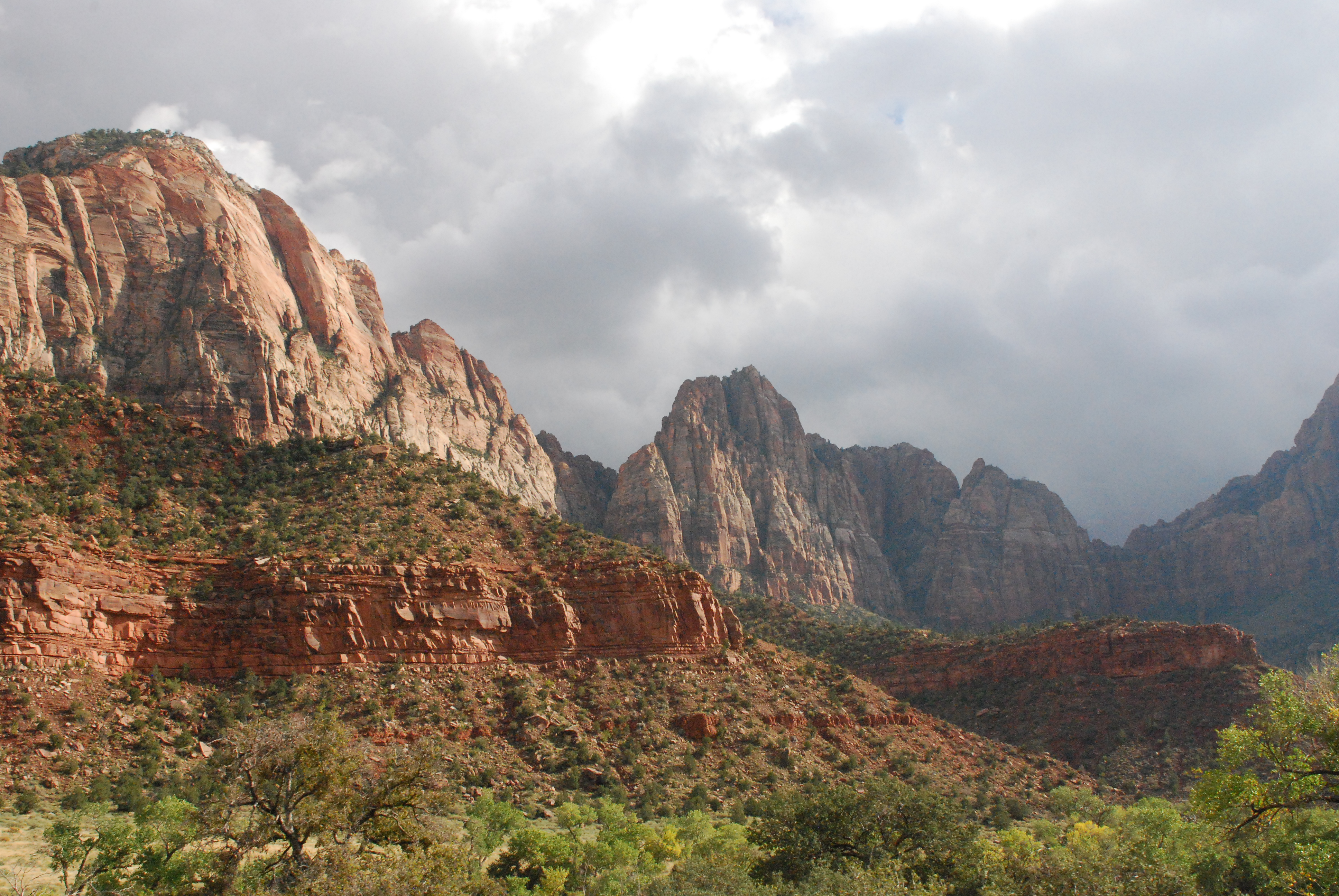
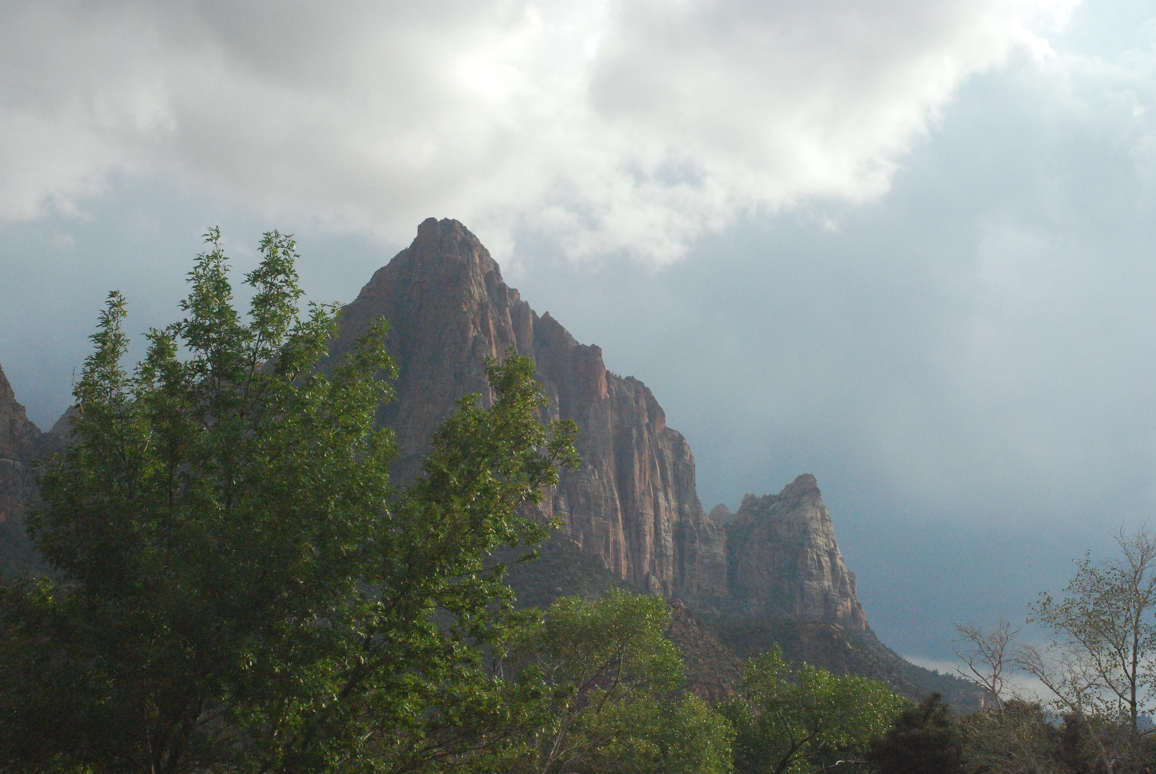
Zion – place of refuge
More Zion, this time at our leisure. We did several of the shorter hikes. This park was all carved out by the Virgin River. Its scale is comparable to Yosemite, but there’s no evidence of glaciation here.
Driving south in Utah and across the corner of Arizona. The topography still magnificent. Came to find that it’s part of the same Virgin River complex as Zion National Park. Plucky little river, that!
Farther southwest into Nevada … flat, desert, boring.
We expected to see Las Vegas much sooner than we did. They apparently don’t sprawl like some SoCal cities.
Hunted down a place-to-stay motel. The GPS was trying to entice us into staying at one of the hotels on the strip. But ya’ know what? After the Rockies and Moab and Zion, nothing in Las Vegas could be that splendid. So we’re in Las Vegas, but barely. Well south of the strip.

|

|

|

|

|

|

|

|

|

|

Rain, rain …
Rainy ride from Orem
Bryce turnoff in the rain was a turnoff.
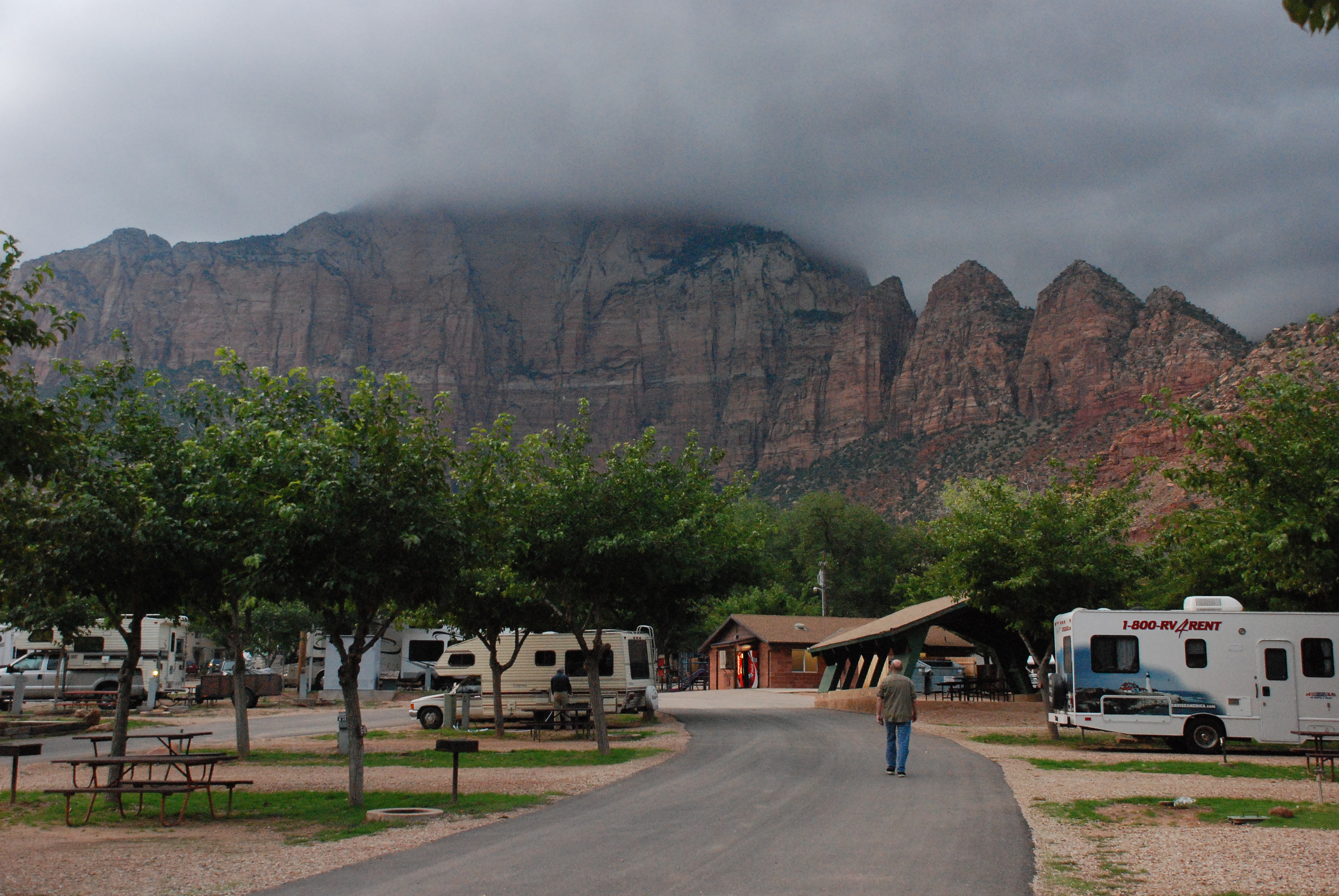
Zion NP quick view – we rode the shuttle bus through the park and back without getting off at any stop. But it persuaded us to stay for a night in a nearby RV park (Springdale, UT) for a good go at Zion tomorrow.
This blog is sparse on words. There are simply no words adequate to describe the magnificent sights we’re seeing!
Enjoy!
Sum pics


Next Post
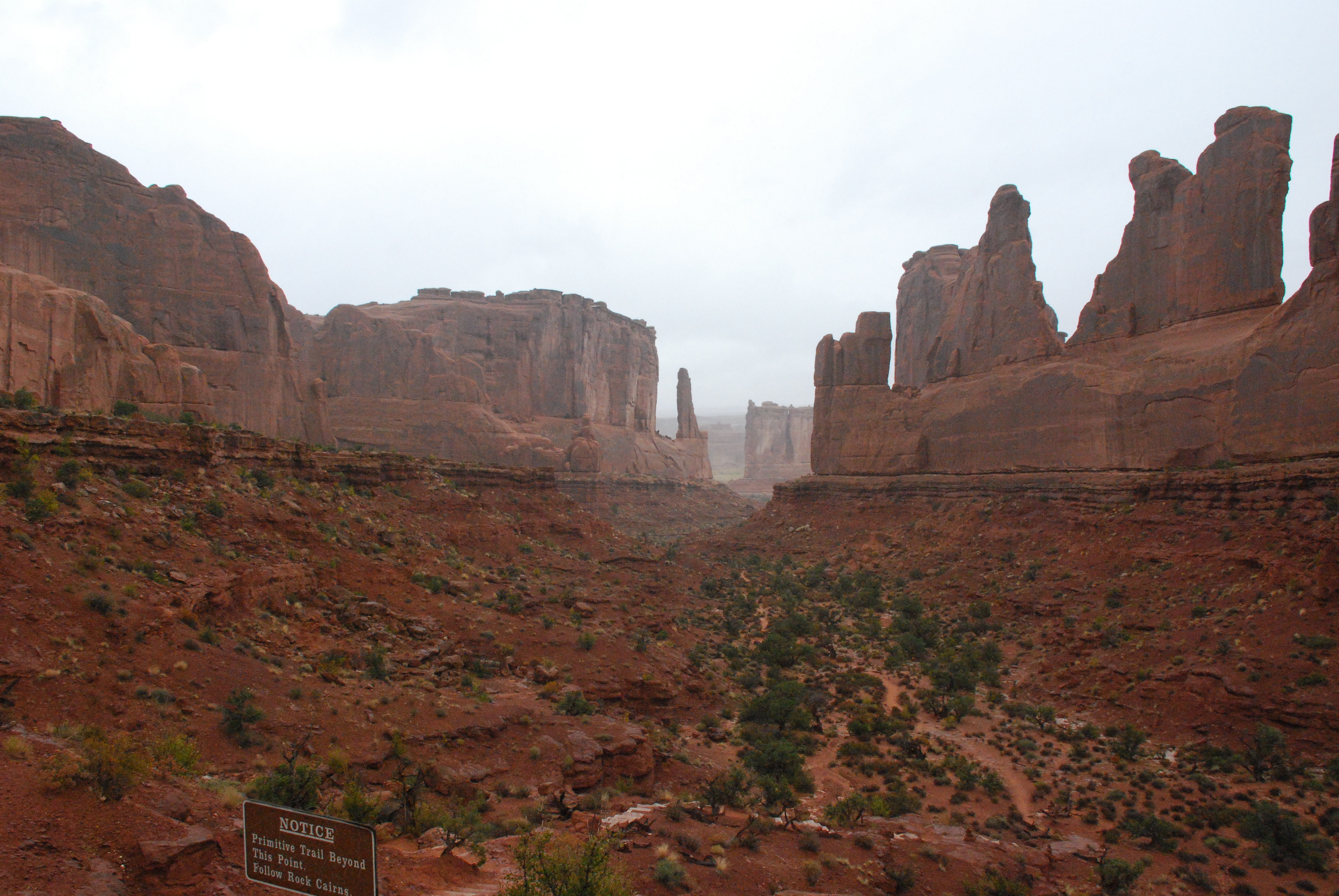
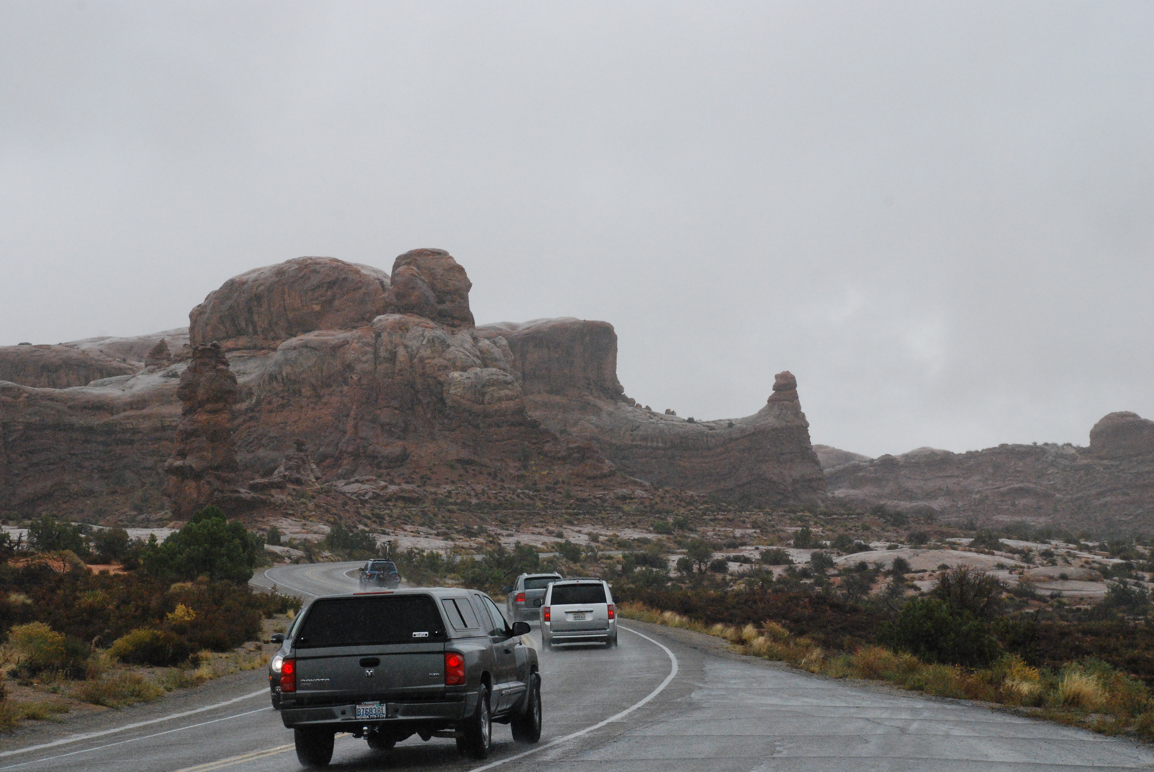
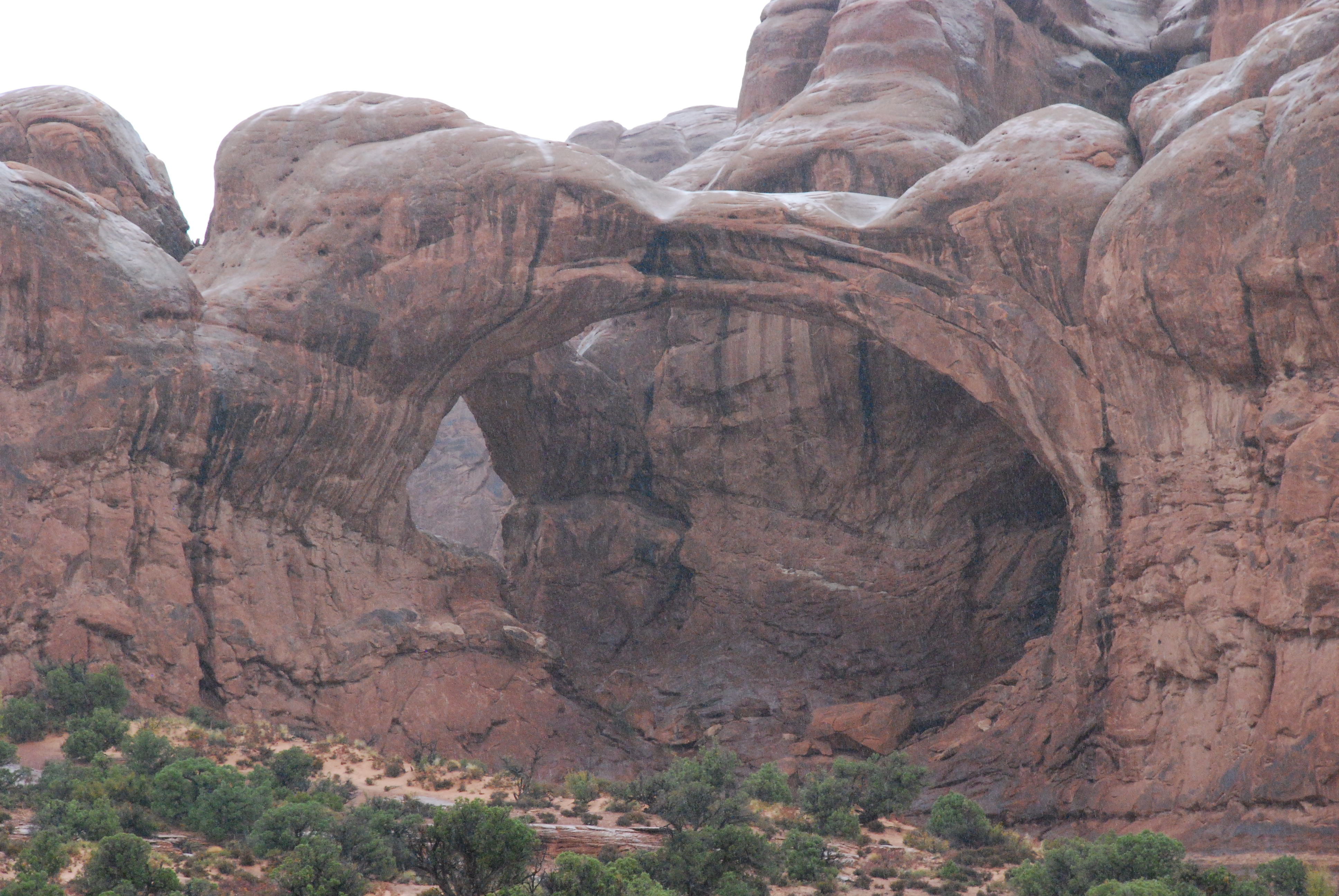
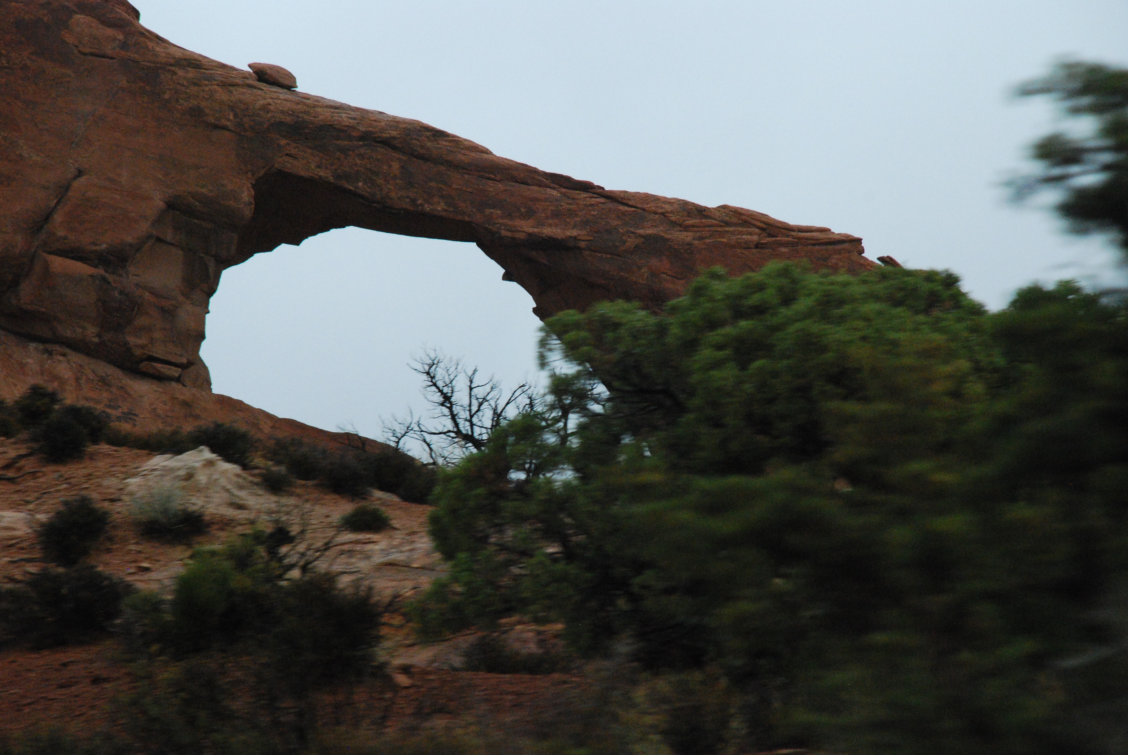
Arches in the rain – nice to have no crowds.
Shame that god didn’t put the arches nearer the road.
Nonetheless, truly awesome spectacle.
Most boring stretch of the road … Hwy 191 from I-70 to Price. Even more so than flat, flat Iowa and flat, flat Nebraska!
Grey sky, grey road grey country.
Wasatch … nice background these Orem folks have!
Good visit with B’s sister and nephew, and a good meal shared by all.
If they hadn’t been digging up I-15 into Orem, life would be excellent.


Wow! And again, Wow!
A gorgeous, clear day. Opened the door to the veranda and discovered a rippling stream in the ‘backyard’. It was absolutely wonderful!
Faced the Rockies, at 11,200 summit in the summit at the Eisenhower Tunnel in a 5000-lb. vehicle with a 2.1 litre engine with 90 brake horsepower. She did OK! Nothing broke. Nothing burned. Nothing got hot.
After the tunnel, it was anti-climactic for a bit. It was easy going through Vail, and a second summit at 10,500 feet (not as steep and in-your-face as the first one … I guess that’s why they call it the “front range”). And then a gentle roll down towards Grand Junction with some beautiful vistas of the White River and the cliff faces, and later the Colorado River.
At Grand Junction, we decided on tactics, and felt that we wanted to go to Arches National Park before heading north to Provo, UT. Heading along I-70 to Hwy 191, B. said, ‘here’s smaller road to get there, Hwy 128. Feeling doubtful, S turned off for the road, and before long it was *WOW* – huge red sandstone cliffs and etched towers. It’s a bit like the Grand Canyon, you can’t really describe it. Just awesome.
The lady in the Visitor center told us not to go to Canyonlands National Park tomorrow, as we would most likely be a lightning rod for the forewarned storms, so we won’t. But we’ll certainly go to the Arches NP.
So now we are here in an RV park in Moab, celebrating an awesome day.
Wow! Rockies! And a bonus … Wow! Moab!

outside our motel

snow-covered mountains
Ascending
It was *cold* this morning in Nebraska. Low 30’s, I’d estimate.
For a very long part of this route, we were driving along the Platte River (South Platte, I believe). Usually, we couldn’t see it. On occasion it came close enough to the road to provide some nice scenery.
We took the short cut to Greeley across Highway 14 in northeast Colorado to see the Pawnee National Grasslands. We expected to see some native prairie, undisturbed for lo these eons, but all we saw was typical agricultural activity.
Shrugging, we turned off to visit B’s sister and niece to spend a little with time them and see their ‘new’ (we hadn’t yet seen it) house.
We then drove down to Denver to rendezvous with B’s brother. He has a great apartment on the 24th floor in the middle of the city with the most magnificent views of the mountains and downtown. B’s brother treated us all to a superb meal at Cucina Colore.
Being in a large-ish city feels just so different after all the corn.
Now we’re in Idaho Springs, 7,500 feet elevation, up from about 2,500 feet when we started out today.
Tomorrow, we have some REALLY big hills to climb. There’s a storm coming in from the West, and we want to be well clear of 12,000 feet before that starts showing its face.
 |
| South Platte River |
 |
| there are mountains way off there |
 |
| view from the 24th floor |

You must be logged in to post a comment.