Cedar Breaks & Parowan Gap Petroglyphs
I (Simon) had never heard of Cedar Breaks NM. It looked pretty close to Cedar City, where we are staying, so we thought, why not?
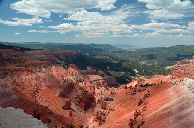
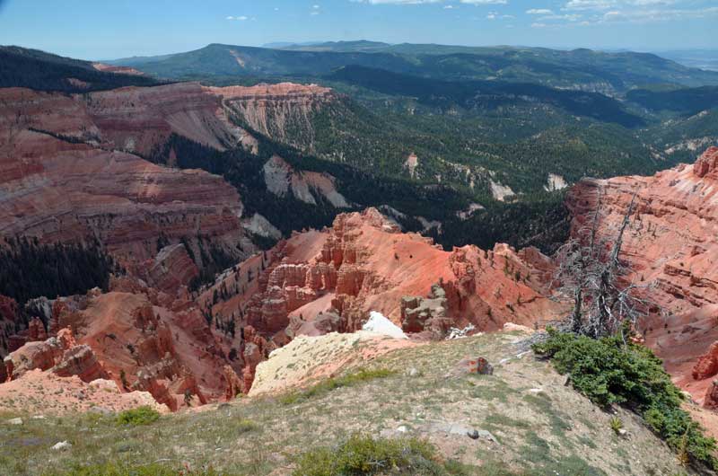
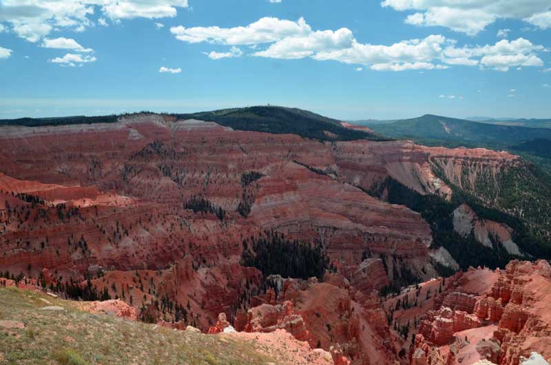
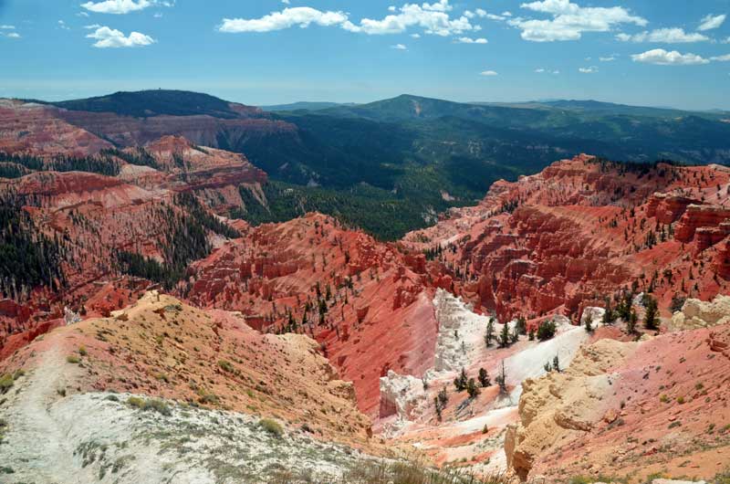
We’re really pleased we did, as it’s an amazing ‘tear’ or ‘break’ in the landscape about 10,000 feet above sea level. Getting up that high from Cedar City proved interesting on Hwy 14 – twist and up, twist and up, with certain death in case of a driving error or blow-out. Temps were in the high 60’s (compared to mid 80’s down the hill) and jackets were worn.
We rolled down the hill through Brians Head, and down into Parowan. B piped up, ‘Why don’t we look for the Petroglyphs?’, ‘Why not?’, sez I.
The map we had was more like the Tube map for London than anything you could actually navigate with, and neither the Garmin GPS nor the Google maps knew anything about the ‘Petroglyphs. So, I winged it, and ended up on a dirt road, dust flying. Eventually, on ‘Gap Road’ (should have been a clue) . Google maps decided to announce our arrival about 5 miles too early, and the Garmin feigned complete ignorance. We passed the ‘Dinosaur Tracks’ (Really?) and eventually came across the place. Also pretty amazing, in a different way.
Pictures follow:
Cedar Breaks
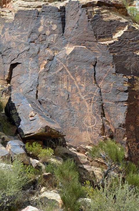
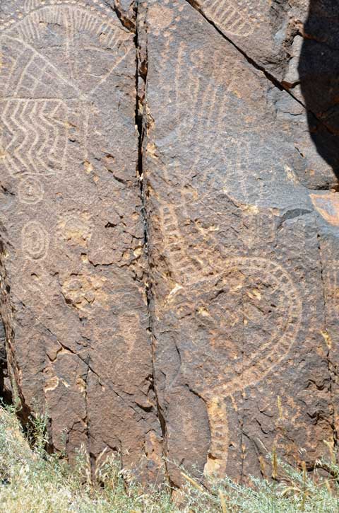
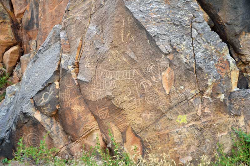
Parowan Gap Petroglyphs
This petroglyph was probably the most striking. It depicts (apparently) a tribe leader who was killed in battle. You can tell he was killed as i) he’s upside down and ii) he has an arrow through his head.
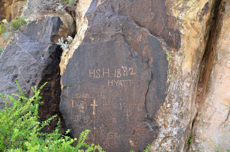
Petroglyph or vandalism? The Mormon explorers came through here on their way to set up the town of Parowan, and left their mark.
Red Rock Canyon & Mt. Charleston
Falling off the mountains down into the Mojave desert floor, it seemed to get hotter and hotter, even though we couldn’t tell, we had the a/c on.
We arrived at our destination in Las Vegas, the Riviera RV Park, on the east side of town. A bit run down, but ‘workmanlike’, it was plenty adequate for what we wanted – somewhere to take a break from driving, and to see some local geology.
But it was hot, 110 degrees hot. The trailer’s 13.5 kbtu couldn’t keep up with it, but it was tolerable at 85 or so. Outside it was an inferno.
Next day – 15th August, we set off for Red Rock Canyon, on the west side of town. Oh my, the traffic lights in Las Vegas take an …..a…….g…….e to change (and why is it always red for us and green for the other guys?).
Let’s just say this, compared to Las Vegas, Red Rock Canyon is just charming and wonderful. Not the hugest, biggest vistas in the world, but a little bit of a break from the heat and very eye-friendly.
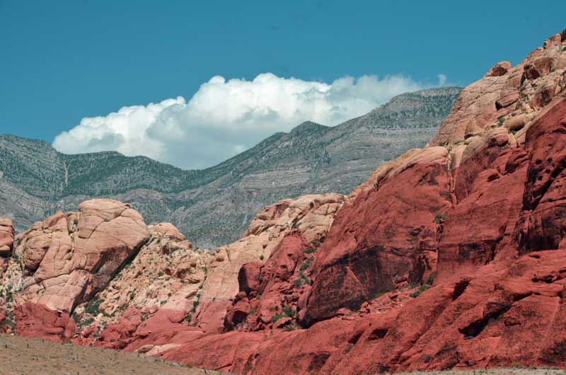
The eponymous red rocks. In the background is the older grey rock.

The ‘side-thrust’ fault can be seen in this image, where the newer red rock is under the older grey rock. Geology is fun!
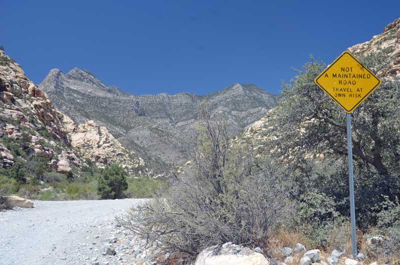
Up at the very top of the canyon was this dirt road heading up and over the hills to the other side. Yep, we’re wimps.
 There was this climber who seemed to get a panic attack climbing down this face. He took ages to regain confidence, and was last seen hanging in free air just below where he is in the photo, slowly letting himself down. Phew!

B’s money shot, right by her open car window.

Mt.Charleston was so high that all our pictures of the valley below were so hazy that Photoshop could do nothing with them. This one is kind of pretty, but gives no idea of the scale of the place. And it was cool – 70 degrees or so. There’s a neat campground up here too. No 40 footers, though.
Holcomb Valley
Thursday 13th August. Still at Serrano cg, Big Bear, we took a short hike to Big Bear Discovery Center, where we discovered a number of things:
That the ‘movie’ that was on repeat, describing what was outside the center was the lowest ‘fi’ grainy ‘remastered in 2007’ Ken Burns special (a lot of zooming around low quality still photos). The cognitive dissonance hit you in the face when you stepped outside the center.
That it would have been an even shorter hike if we had walked up the road, instead of the very pretty marked trail.
That there was a gold rush a few miles north of here about the same time as the other gold rushes were happening in California, and that there is a network of dirt roads that lead to some remains of what went on. So we picked up the brochure for ‘Gold Fever Trail’ and that’s where we went.

This was ‘Two Gun Bill’s Saloon’. A few logs scattered around, which might or might not have fitted together at some time. Oh, and the real site of the saloon was two miles east of here.
The Grasshopper Quartz Mill. What remains is apparently a water pump and part of a crushing device.

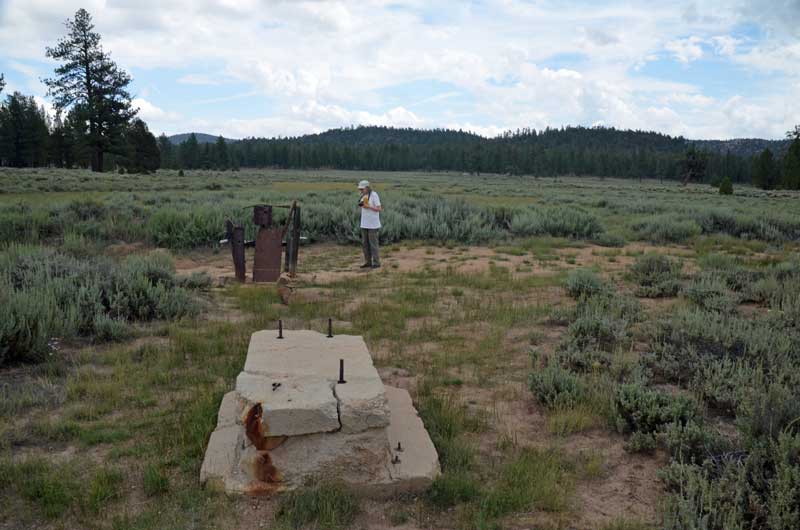
Belleville Cabin. It was ‘moved’ here to exemplify the type of cabin that would have been here if there was one here. I think it was ‘moved’ here from a place that makes cabins, as it looks like it was built last year.
Joking aside, it seems amazing that so little remains of what must have been a huge community.
The start of the ‘Grand Adventure’
B was frantically double bagging everything to protect it from the evil ‘sulphuryl fluoride’, the stuff they use to fumigate against termites. It turns out that we are such pack-rats that we had more than a dozen ‘double bags’ of stuff, for dry food, medications, freezer stuff, fridge stuff and etc. and etc.
This fumigation is due to happen some time in mid September, but we were on the point of leaving for a 6 week ‘Grand Adventure’. I’d put the Jade plant outside, as instructed, and some effing person had already purloined it. Oh well, who can you trust?
Anyway, B got it all done, and I loaded the trailer and tow vehicle. Time to pull out all the wall-warts and shut down the computers. Uh-oh, Micro$oft had decided to update my desktop, and shutting it down was taking f o r e v e r. Screw that, just hit the ‘Off’ button for a few seconds, worry about it when we get back.
So, off we set, up the I-15, only to realize that we hadn’t put on our new Aero 2 extension mirrors. Pull over to hwy 395 and the entrance to the Lawrence Welk resort(!) and fix that. Turns out that these mirror extensions are the bees knees – now I can see who is right behind me.
Ponder Nessy Burgers for lunch, but then decide to drive through to our destination – Serrano campground at Big Bear Lake.
Mostly uneventful, except for a weird sway overtaking another travel trailer at 55 mph on the 215. I brought it under control by hitting the manual brake control for the trailer brakes, but there was some considerable ‘pucker factor’.
We were impressed that the Xterra pulled like a trojan up the 330/18. Coolant temps stayed low, and we sort of kept up with traffic.
The campground is just fine

and an easy walk to the lake

Sierra Nevada – traveling up the West side and down the East side
The 13th April, an auspicious day, marked the start of our Sierra Nevada adventure. Why? Because I (S) had toe surgery planned for the end of May, which would cause me to be ‘un-trailered’ for at least 12 weeks, and like the soccer guys, wanted to ‘get my retaliation in first’, and this was the last opportunity to go.
There will be more pictures than text, but some amount of preamble might be fun.
There wasn’t too much planning. We decided that the first night would be at California Hot Springs, and then we would just wing it thereafter. Why there? Because we’d done Lake Isabella multiple times, and this was a different launch point.
We set off, for us, early, at 9am, from San Diego and headed up the I-15, hoping to avoid the crush on I-5, I-405 and the prelude to the Grapevine. Um, no. The 210 was a parking lot, grrr, and on the Grapevine ‘up bits’ we overtook all the laboring commercial traffic, and down the ‘down bits’ they overtook us, so it was a kind of a motoring ballet dance.
Eventually, we filtered off onto CA-99, which was much less intense, then headed east up into them there hills to California Hot Springs.
We had already decided to stay at Quail Valley ‘Recreation Village’ rather than at the Hot Springs resort, which turned out to be a good choice as that latter was closed for RV’s.
Myron, the owner, was a hoot, regaling us with tales of the misdeeds of his long term residents, and his ‘innocent’ retaliation. In one instance, he suspected that a long-timer was stealing his gas. Long story short, he swapped the gas cans for ones with water in. The next day, the long-timer’s car wouldn’t start. L-T’s pals did stuff with the points and carburetor. Myron wandered over and casually asked whether L-T had stolen some of his gas. L-T exploded with indignation. Myron shrugged, and remarked that he’d moved the gas cans and the ones there were now water. Next day, L-T was observed draining his gas tank and lines and didn’t stay much longer at the park.
We were the only transients there. Really pretty, we stayed a couple of nights.
 Next morning, we set off up the hill into the mist and fog. Around the intersection with the road up from Lake Isabella, we encountered a pair of very damp and cold looking Harley riders, apparently undecided about which direction to go. Then the sun came out (or we got above the fog?)
Stopping briefly at the ‘Trail of a Hundred Giants’ for a photo op (we’d walked the trail before),
 we headed on through the forest. Like almost the entire trip, it is picturesque, almost beyond belief.
 Starting around Ponderosa, the road starts winding down towards Springville in the Central Valley. If there are any motorcyclists here who have ridden the Palomar South Grade, then this road is like that, but it just goes on, and on, and on, and on.
 Later, when we returned to Quail Valley, we took a hike around the property, and came across 4 fishing ponds, of which B got a couple of very pretty shots.

 Next day, we took it really easy. We drove a mere 75 miles to Horse Creek Campground, right by Lake Kaweah. This once was an Army barracks, but is now an extremely pretty lakeside cg hosted by the Army Corps of Engineers. No hookups, but loads of space – if you don’t like your neighbor, you can just move.
The live-in volunteer camp host was great, and tried to recruit me (S) to come and work there.
Because we have a national Parks Geezer Pass™, it only costs $10 per night.


 Simon, cooking.
 Next day, we set off up the hill into the Sequoia National Park, and Kings Canyon NP, returning via an extension of the Sequoia National Forest.
Again, the ‘Geezer Pass’ saved us $20. I, Simon, probably had a brain fart when I first ‘did’ this park in the last Millennium, because what I remember is completely different from what we experienced. Nonetheless, it was all good. We had fun joshing with the volunteer at the visitor center and did quite a bit of hiking up and down the trails. A side trip into Kings Canyon NP added to the pleasure.


 King’s Canyon
 On the way back to Horse Creek campground, we diverted via ‘Hogback Road’. Oh my. That is all. Talk about wild rides. Good job we didn’t have the trailer on the back.
Next day we decamped and headed for Gold Country. We decided to veer from the GPS proposed course up Hwy 99 and headed North on 41. Then, the weirdest thing happened, the GPS insisted on telling us to ‘GO BACK’ to 99, and that it would take ‘FOREVER’ to get to our destination if we didn’t, until we got within a couple of miles from Mariposa, when it said, ‘OK, then, if that’s how you want to play this, you’ve just saved two hours!’ WTF?
We got a bit snarled up in Jamestown after having visited the local Safeway for supplies, but soon enough we arrived at our destination in San Andreas – Gold Strike Village. Big shout out for this place, it’s clean and well-tended. The only problem I encountered was that our neighbor’s water hookup leaked, and I was attacked by mosquitoes as a result when I was preparing a meal on our outside grill.
Next day we headed South back to Jamestown, and it turned out that they were having a wild flower run on the local RailTown steam railway. B is always up for steam trains.

 We had to pay extra for this trip as it was a ‘Wildflower Special’, but sadly, there were not many wildflowers around – too dry, too late. One of the state park rangers on the train’s spouse planted some plastic wildflowers…
 And there were other treats..


 Columbia State Park is fun

After three nights in Gold Country, it was time to head out. Up SR49 to Placerville and SR 50 over the top and down the other side to Lake Tahoe. That’s a wonderfully pretty drive, and no problem with a trailer. We encountered an utter jerk who was holding up dozens of others in anticipation of finding a parking spot near the lake, but some folks are resistant to education and learning good manners.
We headed east to Hwy 395 and trundled south through some spectacular country…
 …to arrive at Lee Vining and eye-wateringly spectacularly high gas prices. And wind. Did I say wind?
Next day we headed south to Bishop and the Law museum. Oh my, this is a wonderful place to get an understanding of history hereabouts. Billed as a railway museum, it seems more to document the mining and general way of living hereabouts, with the railway almost as a side comment.

 To Lone Pine, and Boulder Creek RV Park. A lot has been posted about this place at the Lance Owner’s of America Website , and who are we to disagree.
Alabama Hills and Whitney Portal


 Postscript: I deferred the surgery, so I’m still, slightly, on two feet. And raring to go for our next adventure.
Corny
 Corn is what (amongst other things, including a bell pepper similarly home grown) we ate tonight. They tasted yummee, and only took about 70 days to mature from seedlings. The darn things are trying to push the roof off our raised bed garden.
In other news, my Nexus 4 developed a crack across the back of the phone: 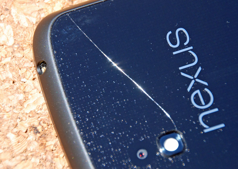 I hadn’t dropped it on any hard surface, and it has always been in the ‘official’ bumper case. Anyhow, I shipped it back to LG in Texas, and just over 2 weeks later, a replacement phone arrived. It has to be noted that if it had been an Apple product, all I would have had to have done is take the faulty one to an Apple store and it would have been replaced and activated there and then. But anyway, for the most part, the Google backup system works just fine and all my apps and data were restored in a couple of hours.
I like it. It’s nice to be positive about stuff 🙂
Sufferin’ Succotash!

‘Oh what a beautiful morning…….
The corn as is high as an elephant’s eye…’
It’s only been there barely a month and it’s trying to break out.
Squash + Pluot
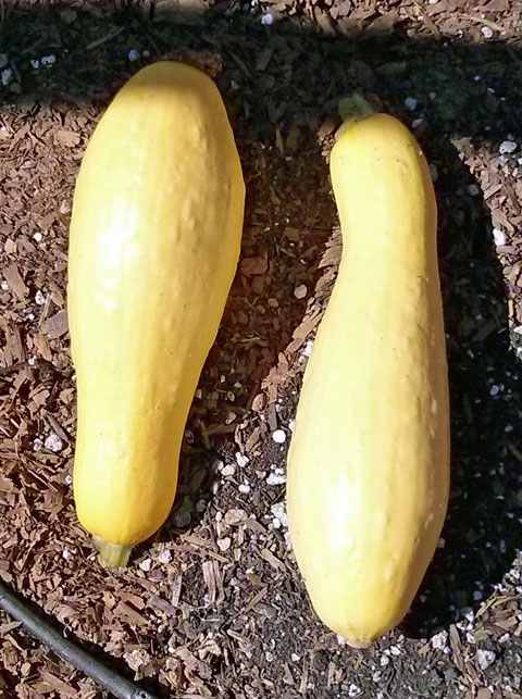 Whoop de do! We harvested these guys from our garden plot yesterday. I’m so impressed with myself that a little nuclear fusion from the sun, and a little free irrigation water from the Colorado River has made these veggies for us.
But, what to do with them? I did the standard ‘put them under the grill (broiler) and throw salt, pepper, garlic and olive oil on them’ yesterday, but they still didn’t taste of much.
But today, we got a Porterhouse steak from Staters, and I sauteed the roundels of squash with, guess what, garlic and salt and pepper, but also a chopped up Pluot from our CSA box. Yummee 🙂 Seriously.
Chromecast – muy cool
So we got the Google ChromeCast dongle yesterday, and having read the reviews, I was prepared to be underwhelmed. Certainly, Roku and Apple TV have way more things that you can do.
Not so fast. The way it works is that you can use any device (I tried Nexi 4, 7 and 10, and iPod touch) to direct a stream from Youtube and Netflix to the device, and here’s the kicker, you can literally turn off (hard shut down) the controlling device, and the Chromecast will keep playing. So the stream is going directly to the Chromecast, not via the controller. The quality is excellent, even over our congested 2.4 GHz wireless neighborhood.
The downsides are 2:
1) There aren’t many apps yet that implement the ChromeCast API – for Android, it’s the above Netflix and YouTube, as well as Google Play Movies. For iOS, it’s just YouTube and Netflix.
For PC’s and Macs (I don’t know about Linux) it’s just the Chrome browser with the downloadable Chromecast extension (which can be used in ‘incognito’ mode, for those of us who are paranoid about Google tracking our usage).
2) This Chrome implementation, in beta as yet, is a bit lame, as it simply ‘mirrors’ what you see in a Chrome browser tab, but it does let you browse local and network files for media content. Functionally, it’s not as comprehensive as an HDMI cable from the back of your computer to the TV, or even Miracast, but hey, it’s only $35 for the ChromeCast dongle.
What’s really neat is that the API for it is now out there. It is to be hoped (and prayed) that apps like Skifta and all the other media players will implement it so that we can wirelessly watch all of our device, local, network and ‘cloud’ content on our HD TVs.
Promising.
Community Garden update
 In a few short weeks, our garden has grown. It’s pushing up hard against the dry hot season. so we’re not really sure what’s going to work and what isn’t. But, everything is growing like crazy. However, nothing except the Jalapeno is anything like ready to crop yet.

You must be logged in to post a comment.