Archive
Next Post
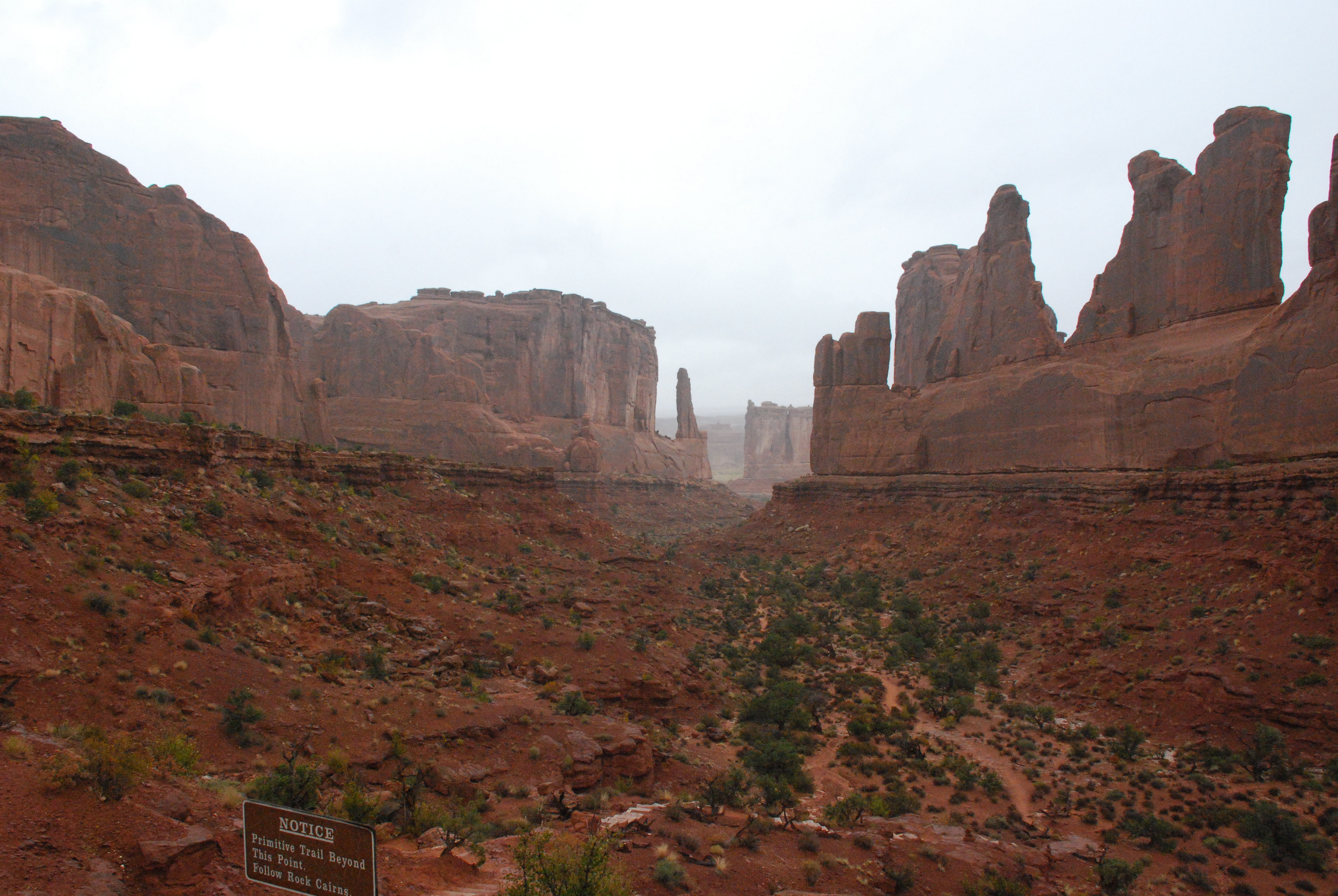
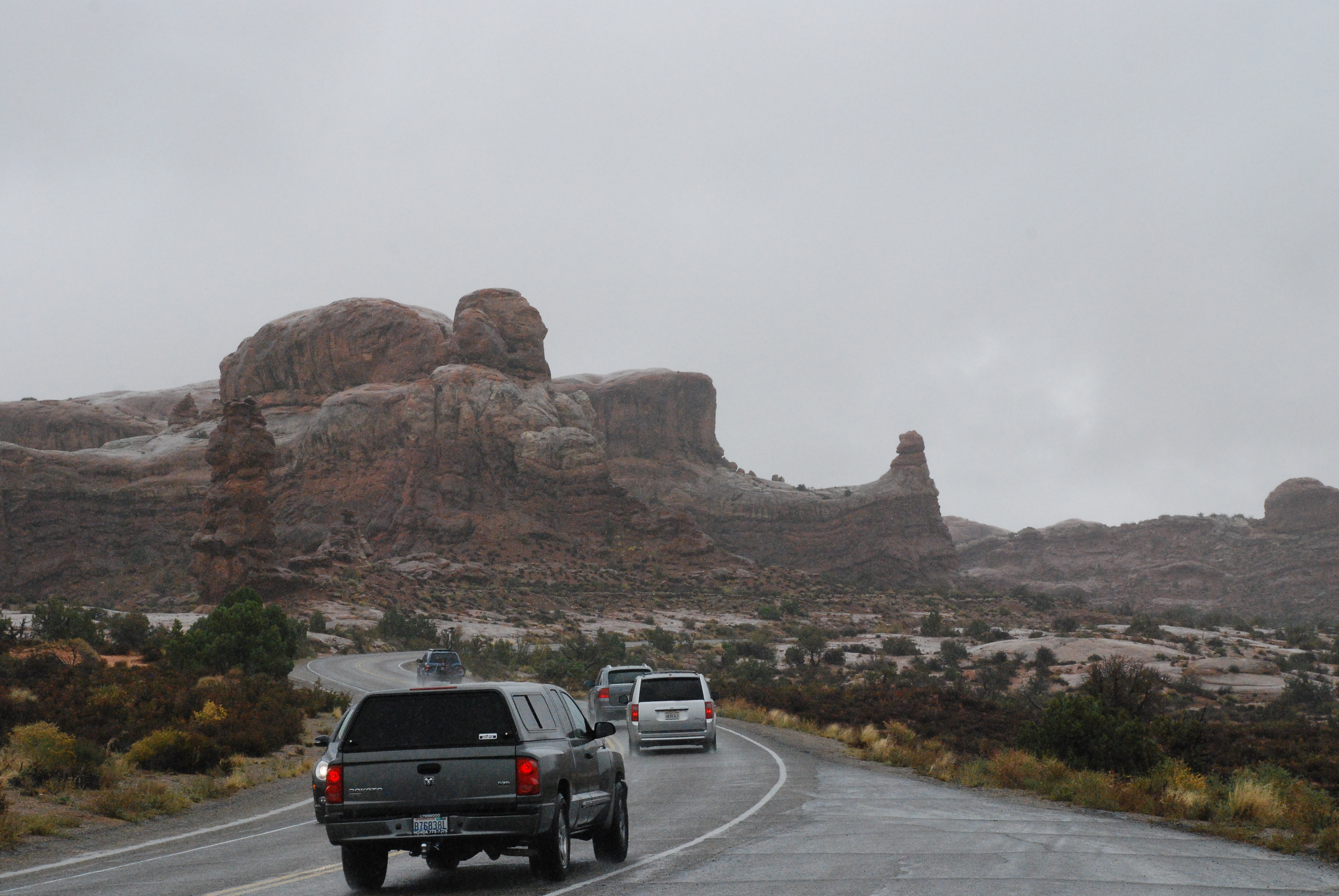
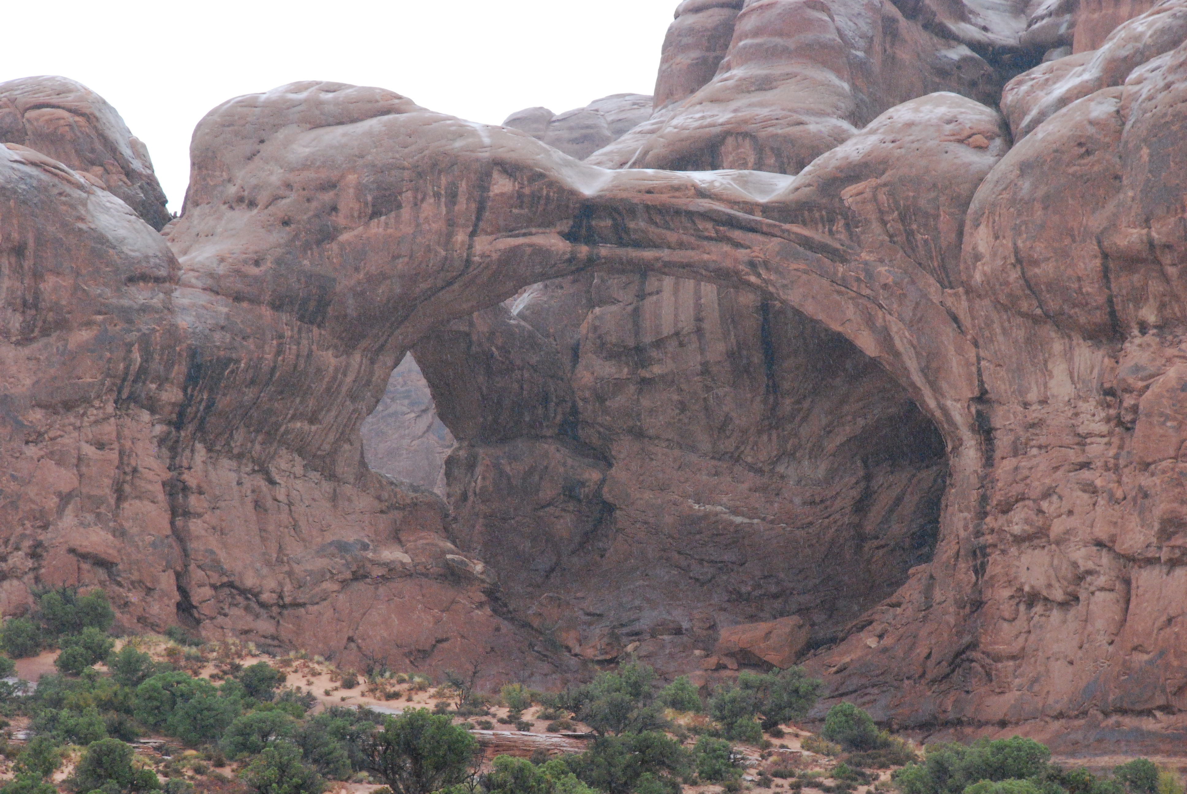
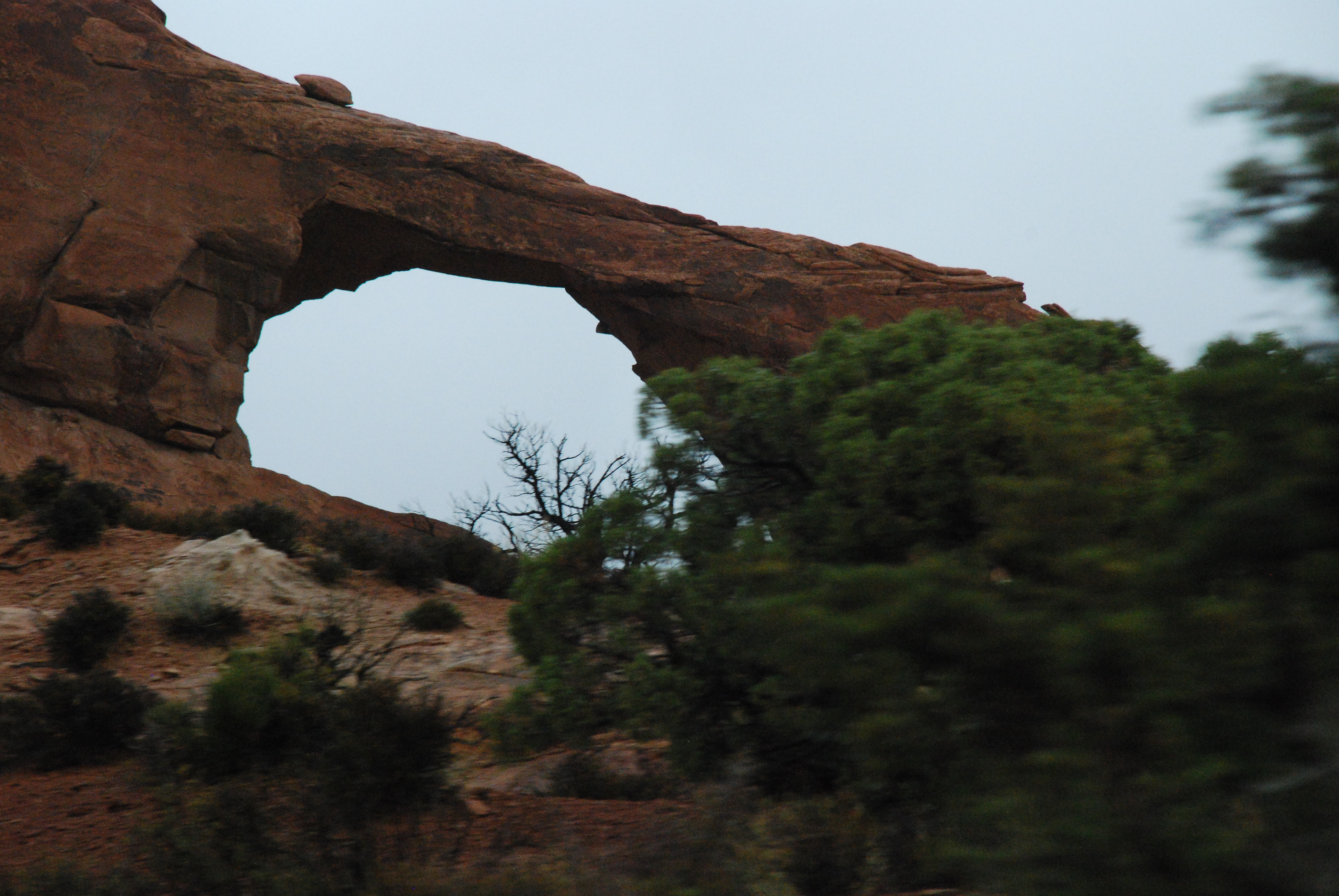
Arches in the rain – nice to have no crowds.
Shame that god didn’t put the arches nearer the road.
Nonetheless, truly awesome spectacle.
Most boring stretch of the road … Hwy 191 from I-70 to Price. Even more so than flat, flat Iowa and flat, flat Nebraska!
Grey sky, grey road grey country.
Wasatch … nice background these Orem folks have!
Good visit with B’s sister and nephew, and a good meal shared by all.
If they hadn’t been digging up I-15 into Orem, life would be excellent.


Wow! And again, Wow!
A gorgeous, clear day. Opened the door to the veranda and discovered a rippling stream in the ‘backyard’. It was absolutely wonderful!
Faced the Rockies, at 11,200 summit in the summit at the Eisenhower Tunnel in a 5000-lb. vehicle with a 2.1 litre engine with 90 brake horsepower. She did OK! Nothing broke. Nothing burned. Nothing got hot.
After the tunnel, it was anti-climactic for a bit. It was easy going through Vail, and a second summit at 10,500 feet (not as steep and in-your-face as the first one … I guess that’s why they call it the “front range”). And then a gentle roll down towards Grand Junction with some beautiful vistas of the White River and the cliff faces, and later the Colorado River.
At Grand Junction, we decided on tactics, and felt that we wanted to go to Arches National Park before heading north to Provo, UT. Heading along I-70 to Hwy 191, B. said, ‘here’s smaller road to get there, Hwy 128. Feeling doubtful, S turned off for the road, and before long it was *WOW* – huge red sandstone cliffs and etched towers. It’s a bit like the Grand Canyon, you can’t really describe it. Just awesome.
The lady in the Visitor center told us not to go to Canyonlands National Park tomorrow, as we would most likely be a lightning rod for the forewarned storms, so we won’t. But we’ll certainly go to the Arches NP.
So now we are here in an RV park in Moab, celebrating an awesome day.
Wow! Rockies! And a bonus … Wow! Moab!

outside our motel

snow-covered mountains
Ascending
It was *cold* this morning in Nebraska. Low 30’s, I’d estimate.
For a very long part of this route, we were driving along the Platte River (South Platte, I believe). Usually, we couldn’t see it. On occasion it came close enough to the road to provide some nice scenery.
We took the short cut to Greeley across Highway 14 in northeast Colorado to see the Pawnee National Grasslands. We expected to see some native prairie, undisturbed for lo these eons, but all we saw was typical agricultural activity.
Shrugging, we turned off to visit B’s sister and niece to spend a little with time them and see their ‘new’ (we hadn’t yet seen it) house.
We then drove down to Denver to rendezvous with B’s brother. He has a great apartment on the 24th floor in the middle of the city with the most magnificent views of the mountains and downtown. B’s brother treated us all to a superb meal at Cucina Colore.
Being in a large-ish city feels just so different after all the corn.
Now we’re in Idaho Springs, 7,500 feet elevation, up from about 2,500 feet when we started out today.
Tomorrow, we have some REALLY big hills to climb. There’s a storm coming in from the West, and we want to be well clear of 12,000 feet before that starts showing its face.
 |
| South Platte River |
 |
| there are mountains way off there |
 |
| view from the 24th floor |
What *do* we all talk about, all that time on the road?
Various stuff. Here, for example, is the list of stuff we noted down to google for answers. We’ll edit this and insert answers as we find them.
Find out what that tiny town was that we found by going off even Highway 30 to the original, old highway 30. |
| TBD |
How do the train engines that are pushing from the rear get controlled? |
| Ron D says: They have an engineer in them. In the 1960s they experimented with radio controlled helpers, but they went back to staffing them with an engineer and fireman. This makes sense because many times when the “helper” engines are done pushing a train up the one specific grade that needed it, the helpers will return “light” (no cars to pull) to their base and wait for the next train that needs their assist. They would need an engineer to perform this task. Ron also adds that they calculate how many engines a train needs based on load and the grades it must go on, etc. Sometimes they just use the extra engines for the tough parts and that saves them from having 10 engines the entire trip. The helpers help with braking when it’s a downhill section. |
What do they do with all those bales of corn straw? |
| B says: Best I can found it’s used for feed and/or fuel. S adds: Why aren’t they using it for building structures, similar to hay-bale houses? |
What’s all the anhydrous ammonia used for in grain country? |
| Ammonia Addition to Whole Plant Corn or Stalks. Anhydrous ammonia or water- or molasses-ammonia mixes can be added to whole plant corn and corn stalks at the time of ensiling (Huber et al., 1979). Ammonia additions have resulted in the following benefits (Huber and Kung, 1983):
1. addition of an economical source of crude protein |
How much corn does the US grow? What happens to it? |
| Wikipedia says: Maize is the most widely grown crop in the Americas with 332 million metric tons grown annually in the United States alone. Transgenic maize [GM] comprised 85% of the maize planted in the United States in 2009. Within the United States, the usage of maize for human consumption constitutes about 1/40th of the amount of grown in the country. In the United States and Canada maize is mostly grown to feed for livestock, as forage, silage (made by fermentation of chopped green cornstalks), or grain. Maize meal is also a significant ingredient of some commercial animal food products, such as dog food. Maize is also used as a fish bait, called “dough balls”. It is particularly popular in Europe for coarse fishing. |
What caused the Rockies? |
| Wikipedia sez: “Terranes started to collide with the western edge of North America in the Mississippian (approximately 350 million years ago), causing the Antler orogeny. During the last half of the Mesozoic Era, much of today’s California, British Columbia, Oregon, and Washington were added to North America. Western North America suffered the effects of repeated collision as slabs of ocean crust sank beneath the continental edge. Slivers of continental crust, carried along by subducting ocean plates, were swept into the subduction zone and scraped onto North America’s western edge. … For 270 million years, the effects of plate collisions were focused very near the edge of the North American plate boundary, far to the west of the Rocky Mountain region. It was not until 80 Ma that these effects began to reach the Rockies. …The current Rocky Mountains were raised in the Laramide orogeny from between 80 to 55 Ma. For the Canadian Rockies, the mountain building is analogous to a rug being pushed on a hardwood floor: the rug bunches up and forms wrinkles (mountains). In Canada, the terranes and subduction are the foot pushing the rug, the ancestral rocks are the rug, and the Canadian Shield in the middle of the continent is the hardwood floor.
Further south, the growth of the Rocky Mountains in the United States is a geological puzzle. Mountain building is normally focused between 200 to 400 miles inland from a subduction zone boundary. Geologists continue to gather evidence to explain the rise of the Rockies so much farther inland; the answer most likely lies with an unusual subducting slab.” |
If you change your oil and drive 5000 miles in a short time, your oil does not change color. But if you take six months to drive 5000 miles, your oil gets discolored. Why? |
| S says: It doesn’t. It’s just as discolored if you cover the 5000 miles quickly or slowly. Oops … senior moment! |
Is there any virgin prairie left, or has it all been disrupted? |
| B says: Apparently so. “…the Loess Hills proved too rugged to cultivate extensively. For this reason the largest undisturbed prairie remnants in Iowa are found amid these craggy hills.” (Winkler, “prairie, a north american guide”) |
Farmland. Flat.
Driving across Iowa. Farmland. Flat. Actually, there are some areas of lovely rolling hills surrounding the Des Moines River. And some Missouri-river caused areas of geological interest in the southwest corner.
Then, because we have long distances to cover, driving well into Nebraska. Farmland. Flat.
Here we are, at Lexington, Nebraska. Tonight for dinner we had New York steak (of course! we’re in Nebraska!).
Nebraska distinguishes itself from Iowa by having even.more.dust. We decided that the dust announces the movement of farm machinery along the road. Here’s the deal. The roads have an ‘extra’ lane on each side which is deliberately populated with dust. This is for agricultural (read slow) vehicles to use. So, when we can’t see anything, we naturally slow down and reduce the risk of damaging agricultural vehicles, which in this state are naturally more important than anything else.
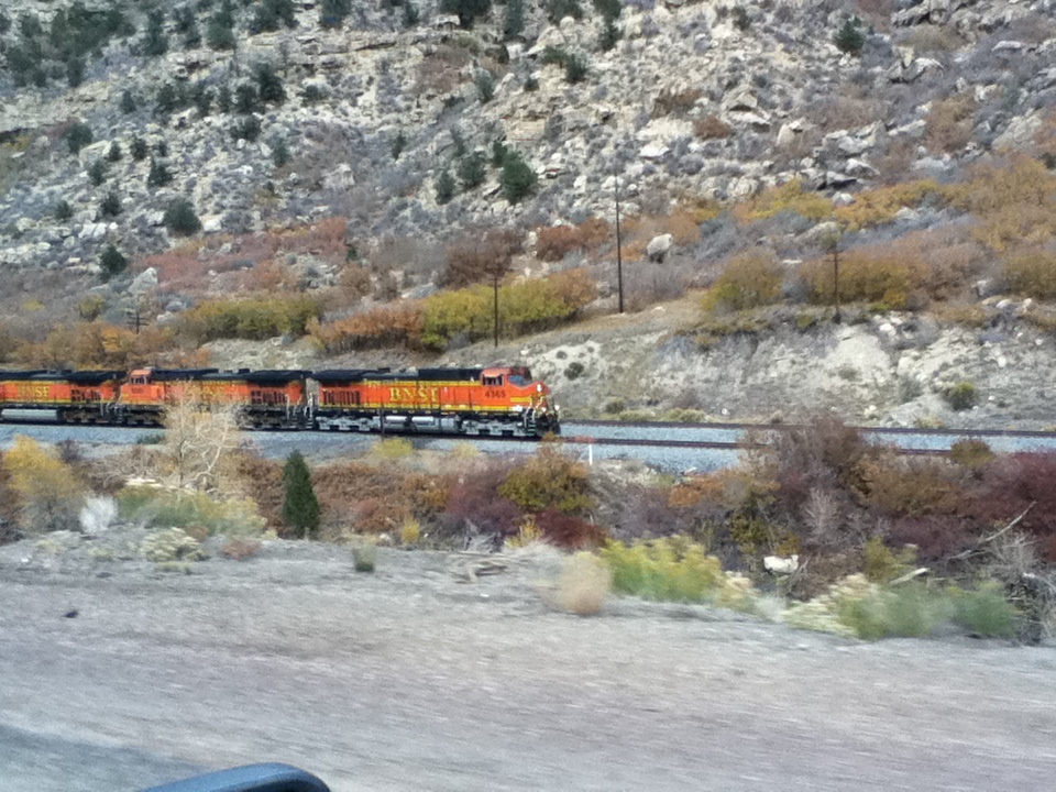
Nice trains, though! 🙂
Take a look at Old link, doesn’t work Try Still slow, but streams rather than downloads

farmland.flat.
Go west, young (and not so young) …
Simon is feeling better today, thankfully. It’s what we in Leftpondia call “24-hour flu”. And S points out is probably not truly influenza but a non-influenza ‘gastric virus’. Two nations divided by a common language!
So we had a re-do of lunch with B’s mum. Much more enjoyable today since we were all happy to be there. We had a good visit.
Eventually, we needed to move westward. So the journey’s latter theme for today is … dust!
We decided to continue on Highway 30 … the Lincoln Highway. We’ve decided that the pace of travel on Highway 30 is much better suited to our Westfalia than the soulless hurtle across I-80.
Eastward out of Aurora, we saw many windfarms. As we got farther west in Illinois, not so much. So B consulted a map and suspects that U of Illinois in DeKalb may have instigated the windfarms. This may be Malthusian (population growing faster than resources allow … and then technology enables better use of resources).
Because the Mississippi has a reputation for being a “mile wide and three feet deep” we expected a very wide bridge. But about a mile into Iowa, we realized that the two less impressive rivers we had crossed were, in fact, the one wide Mississippi!
Later into Iowa, we decided to detour off the current Highway 30 to what we surmised is the original, historic Lincoln Highway, and were rewarded for our efforts by a lovely sidetrip through an old Iowa town. Someone who has much more time could make a journey of taking all the side trips like that!
Tonight we’re overnighting in Cedar Rapids, IA.
Update (S.) Bed bugs are crawling across the USA, westwards. Last night, we avoided staying at the local Super 8 across the street from the La Quinta Hotel, where we did, in fact stay. I was bitten by bed bugs anyway. Can you say itchy?

|
| windfarms |
 |
| roadside attraction |
 |
| a small part of the width of the Mississippi |
Camping, at last!
We didn’t blog last night, since we really, truly camped. 🙂 (S. interjects, Yeah well, we had wifi, but we also had a campfire and good food to enjoy.) So here is yesterday’s post.
So, yesterday. B started out driving. S had driven across the Newell Bridge last night, way high over the river, in the dark, and didn’t like it at all! B likes high places and was delighted to have the opportunity to drive back over the bridge in the daytime, and admire the river scenery on both sides. S closed his eyes and wished for us to be over the bridge. (S. interjects, No he didn’t, he took a video of the experience.)
We’ve been following the Lincoln Highway, which is one of the first (maybe *the* first?) interstate highway. We drove through and near several old towns. But this is old by US standards, which is new-ish by world standards. Still, it was interesting to see. Until just before Canton, OH, when the Lincoln Highway turned into a soulless interstate. And stayed so, well into Indiana.
B stuck her nose into the map book, and decided that a more interesting route would be to go northward toward I-80 and the southern tip of Lake Michigan.
So we requested of our GPS to send us through South Bend, Indiana. And, oh, by the way, show us a Starbucks on the way. Except, with the recession, many of the Starbucks have closed. So after an hour or so of not finding an open Starbucks, we found one in a shopping mall in Fort Wayne.
To make up for our inconvenience, we took benefit of their wifi connection and called Alice from the mall. Because it’s lovely to talk with her, and because we could. 🙂
Later that evening, we went through South Bend and started looking for lodging near the lakeshore. B had spent her youth living not so far away, but had never yet seen the Indiana Dunes. So we aimed for Michigan City, Indiana as an overnight point.
And to our delight, found both moderate overnight temperatures and a convivial campground. They were having an early Hallowe’en party, that evening, and we dined to the sounds of grownups making silly “I’m pretending to be scarey” noises, and kids making silly, “I’m pretending to be scared” responses. Hooray, camping!

driving away from a weather front

Driving the Lincoln Highway

Hallowe'en at the south shore
Starting back towards home
Some context … Simon drove from San Diego to Baltimore … 2??? miles. If he drove the same distance southeast from Bristol, where Alice lives, he’d cross – having to deal with most of the border crossings – France, Germany, Austria, Hungary, Serbia, Bulgaria, Turkey, and very nearly into Iraq. Except he’d be turned away at the border of Iraq.
Today we didn’t rush out in the morning, and when we did we had a few bits of business to deal with. And then realized that if we got ourselves to the Lincoln Highway (30), we could follow it most of the way to our next planned destination, to visit with my mum. State counts: Maryland, Pennsylvania, Ohio (only just), and overnight in West Virginia (only just … Newell, WV). Lots of lovely fall color, all the more spectacular in the short intervals when the sun broke through the clouds.
Unfortunately, we lost Highway 30 at one point in Pennsylvania, and when we’d regained it we realized we’d narrowly bypassed the chance to visit the Flight 93 Memorial.
No camping tonight! It was chilly enough during the day!

the curve of the road and the depth of the color …

not the road below Banner grade

leaving Pittsburgh
Boyd’s Bears, you’ve completely lost your way!
Teddy bears are my totem. Our condo is overflowing with them … really! There’s not a free surface left that hasn’t been claimed by one of the b’loved guys! Each one of them, some more than others, has given me comfort and solace during life’s small, medium and large trials.
How do I find them? They wave to me. While I’m living my life, and times are stressful, or even when they’re not so stressful, a bear will wave to me. The bear is offering to come with me and give me something to hug and cuddle and relieve my stress, and something to smile at when life seems a bit grim.
Last weekend, I was driving around your area, using a combination of my GPS, my map, and my route description to try to find an obscure place. It wasn’t working and I was feeling fed up. While riding around, I found myself in your Barn’s driveway. “Ah!”, I sighed. “At least I’ll find myself a teddy to share my frustration and enourage me to smile and enjoy and the rest of my weekend, and then to keep my other guys company in my overflowing condo.
So I looked. I wandered. I saw lots of costumed bears. Special-occasion bears. Collectible series bears. They were all working hard at being the best in their genre. But wait …
… I needed a comforting, consoling teddy bear! Not a hard-working speciality bear. So I headed for the Bear Factory, since there I might be able to construct a comfort bear. First thing I saw on the Bear Factory counter was the poster all about the lanyard and the label and the photos and the hard hat … Wait, no!!! I wasn’t looking for a tourist experience. I was looking for a loving, loveable bear.
I roamed, I searched, I hunted for a Bear of Great Comfort. I’m dismayed to report that as hard as I tried, I couldn’t find, in your entire huge Bear Barn, even one bear that waved out to me to simply offer me comfort.
How sad! You’ve lost the entire essence of teddy bears.
Apparently I’m in good company …
Remember my dismay at discovering that our former domain name registrar had information about me that far pre-dated my dealings with them?
Well, it seems this practice is more widespread than I had thought …
*shrug*. Oh, well. The internet is *not* private. Never was. Never will be. You *will* be intruded upon at some point.

You must be logged in to post a comment.